In a previous article we described the success which Arthur Batty of the Ingleborough Archaeology Group enjoyed using Scan2CAD raster to vector conversion software on the Kingsdale Head Project. We concluded by highlighting some of the difficulties which Aisling Mulcahy, a project manager and GIS technician for an Irish archaeological company, was having using Scan2CAD to convert some less-than-ideal scanned images which had been hand-drawn on-site into CAD files.
Aisling has evaluated several automatic raster to vector converters. She described Scan2CAD as “the best” of the vectorization programs which she had looked at. However, she still required some further advice to questions she had about using it more effectively with her hand-drawn plans. Most of these had been produced on-site, often in damp or poor weather conditions. In Ireland, she says “we have a phrase – ‘workable rain’. You can imagine what this means…”
One feature of her drawings was dirt which needed to be removed from the drawing during or after scanning. Another was that her well-executed and attractive pencil drawings had been saved as a JPG file. Unfortunately the combination of soft pencil lines, a JPG file’s quality reduction, poor and variable foreground / background contrast, blurry lines and complex drawing elements with ambiguous paths made her original scan largely unsuitable for automatic raster to vector conversion.
We suggested to her that she use Arthur Batty’s method of making a copy, then inking over the original and scanning that. This would provide sharp lines in black on a white background, ideal for Scan2CAD to get its teeth into.
The complexity of Aisling’s finely detailed drawing of an ancient Irish cemetery made redrawing a time-consuming task. Undaunted, she used a transparent acetate sheet and a fine marker to trace over all the detail and scanned it again. This time, she said “the results I got from Scan2CAD were excellent.” Scan2CAD’s vectorization was quick but the time it took her to redraw all the detail and then edit the vectorized results in AutoCAD made her decide that this method was impractical.
Nevertheless, Aisling persisted with the use of Scan2CAD. By adapting the settings she learned over time how to improve the quality of Scan2CAD’s results. As she got better results, her comments on the quality of vectorization ranged from “OK, just small tweaking afterwards” to “good, just small edits to be done afterward” to even a “perfect, almost zero editing required”.
Having now used Scan2CAD on several projects Aisling is able to comment knowledgeably on it use.
“Scan2CAD works best on clean plans with single pencil lines. If plans are smudged or unclear, the programme draws what it can and the result can be geometric shapes which are not what is desired. Also, if there are multiple pencil lines overlacing other detail, the programme draws all of these. The vertices of the lines can be difficult to disentangle during editing.However, these problems (and their solutions) are the realm of the archaeologist, not of the computer program.
“The software can work to its limits but it cannot distinguish which line to draw and which to ignore… It is not a magician!”
Sharp, clean drawing detail is ideally what all raster to vector converters, not just Scan2CAD, need in order to give a good result. Aisling now accepts that Scan2CAD had a less than perfect start with some of her on-site drawings.
She recommends to other archaeolgists who might have a similar need to use Scan2CAD that “if the weather and working conditions permit, it is time and cost-effective to attempt to draw clean plans. Most of the plans which worked best for me with Scan2CAD were those which were produced in the site office – out of the elements. While it may sound discouraging that Scan2CAD will not vectorize every site plan perfectly, it is still a very useful tool. If it is useful for half the plans, then it is useful!
“I have worked with the settings in Scan2CAD and now get a very good vectorization” she said.
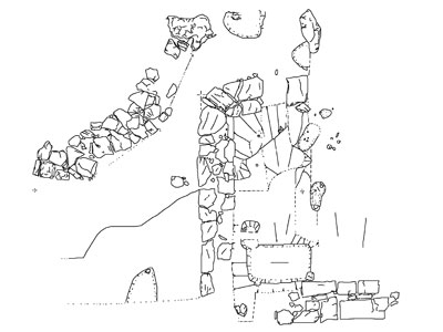
Recently Aisling attempted to use Scan2CAD to vectorize drawings of site plans with stone foundations. One was a plan that vectorized perfectly requiring almost zero editing, “maybe five minutes” she added. The second was a different plan of the same site. This was smudged, resulting in unclear geometric shapes in the centre where the smudging was the worst. Even so, Aisling said that “Scan2CAD vectorized both wood and stone to a good standard. The stone, in particular, takes a LONG time to draw manually. It is a tedious job drawing each stone and cobble!”
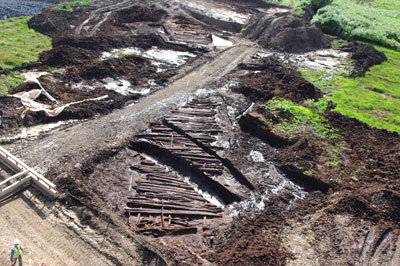
The first part of Aisling’s reference to “both wood and stone” refers to an impressive excavation of what she describes as “basically an Iron Age motorway”. Excavated in 2007, the wooden trackway comprised complex timbers dating from approximately 40BC, making it over 2000 years old. Preserved by the peat of the bog, the trackway is a near perfect example of pre-historic, Iron Age Celtic civil engineering. It is probably one of the largest trackways ever found in northern Europe.
In northern Europe, a historically soggy patch of turf until drained by the modern civil engineer, the construction of ancient trackways across bogs has been a necessity for the last 6,000 years. Over 200 trackways have been found in Irish bogs. These are most commonly found in Counties Kildare, Leitrim, Galway, Longford, Meath, Offaly, Tipperary and Westmeath.
In ancient times the Irish spent much energy and time building wooden tracks that would allow villagers a safe and easy passage across the bogs. In most places bogs could be crossed on foot, by jumping from one dry hummock to another, but on some occasions and during the wetter seasons of the year the bogs were both dangerous or impassable. As a result people made trackways from planks of wood or from thin branches that were woven together, to gain a safe and easy path across them.
The wooden trackway was built to cross a very deep bog, up to 16m in places, from a dry spit of land to a secure dry island. Brushwood and odd pieces of wood were placed in the wettest areas to create a foundation. Runners of birch were placed along the route of the trackway at spaced intervals. Over these were placed large split planks of oak, some up to 7m in length. Some of these planks had mortice joints at the ends and stakes were driven in to ground them. Stakes were placed at either side of the trackway and driven into the bog’s entire length to anchor it. As a bog is a moving entity, the trackway was effectively a floating road. Unless the trackways were constantly maintained and raised in level, sooner or later the growing bog buried them.
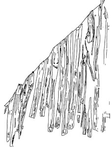
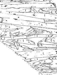
The final result – a Scan2CAD vectorized image of some of the planks in the trackway. © TVAS (Ireland) Ltd.
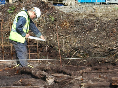
Pre-history’s rising bog levels and the trackways re-emergence today provides work for modern day Irish archaeologists. Scan2CAD was one of several software tools used to document the trackway. Hand drawings of the trackway wood were produced on site. These, said Aisling, would provide a good test of Scan2CAD’s capabilities as the wooden material used for the trackway necessitated that “artistic” lines are drawn to plan more effectively. “The Scan2CAD program handled even these” she said.
Aisling Mulcahy is currently working with two Irish archaeological companies, TVAS (Ireland) Ltd and Icon Archaeology Ltd. For more information on their work, see:
www.tvasireland.ie
www.iconarchaeology.ie


