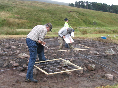
Arthur Batty (foreground) and colleagues from the Ingleborough Archaeology Group producing drawings on-site for the Kingsdale Head Project. © Arthur Batty IAG.
Unlike AEC drawings with their straight orthogonal lines and perfect arcs and circles, archaeological sketches are usually made as freehand drawings on-site in difficult conditions (rain, mud) using pencils (which can be too faint) or pens (which can be too thick and whose ink may bleed, thereby causing a loss of sharp drawing detail). The vectorization of these sketches can be difficult and require workarounds.
One archaeologist who has learned how to get useful results from Scan2CAD raster to vector conversion software is Arthur Batty of the IAG (Ingleborough Archaeology Group), winners of the Association for Industrial Archaeology Fieldwork and Recording Initiative Award 2007. Arthur found Scan2CAD helpful in preparing the IAG’s reports but not before learning what it needs in order to get useful results. He has learned that Scan2CAD reserves its best results for sharp, good quality drawings and scans.
Based in Ingleton, North Yorkshire, England, the IAG was formed in April 1996. It has about 40 members who research the history and prehistory of the Ingleborough District which lies within the scenic Yorkshire Dales. The IAG has conducted several archaeological excavations and investigations in this area in the last four years. One, the Sandymire Project, was an investigation into apparently ancient timbers which had been revealed by receding water levels. These showed evidence of Bronze Age axe work.
For the Kingsdale Head Project, the IAG investigated a rectangular feature discovered within the Yorkshire Dales National Park. This was believed to be Norse in origin. Using skills developed on previous projects, the IAG studied the area using a Penmap and geophysical, topographical and photographic surveys. A small scale excavation of a badly eroded area was undertaken in conjunction with experts from the University of Bradford. Once such a study is finished, the IAG analyse the information and publish the results.

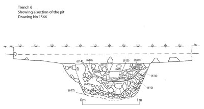
Typical archaeolgical sketch produced on-site prior to re-inking and conversion with Scan2CAD. This is an ancient fire pit, a feature of a site uncovered by the IAG. © Arthur Batty IAG.
“When we first considered trying to create DXF files from our achaeological field drawings, we imported them into AutoCAD as a BMP raster file and then redrew all the lines” said Arthur. “This was not a very accurate way of achieving the desired results. It was also time-consuming. We looked around for a quicker, alternative method and decided to purchase Scan2CAD.
“The first problem we encountered” he said “was that the lines on the original field drawings were too faint and did not vectorize well. Our solution was to photocopy the originals, then ink over the lines on these copies. These were then scanned again and using Scan2CAD converted into DXF files with excellent results. This proved to be much faster and more effective than redrawing in AutoCAD. One benefit resulting from this method of working was that we also got a useful paper copy of the original site drawing for our archives.

The same image after photocopying, inking over the lines, rescanning, converting with Scan2CAD and editing in Adobe Illustrator. “Excellent results” says Arthur Batty. © Arthur Batty IAG.
“Once we had the DXF files, we imported them into Adobe Illustrator to remove handwritten notes and to add text and or more drawing detail. The result was a JPG file suitable for inserting into a publication and which was saved on CD for a digital archive. The recording of archaeological remains from several excavations from the last four years is now taking place. Scan2CAD has been used to vectorize the drawings on all projects. My method gives very good results ideal for publication in a reasonable period of time” Arthur said.
Just after we spoke to Arthur about this, we were contacted by Aisling Mulcahy, a project manager and GIS technician for an Irish archaeological company who had evaluated several raster to vector converters. She described Scan2CAD as “the best” of the ones she had looked at but she still required answers to some general questions about using Scan2CAD. Like Arthur’s, her plans were drawn on-site, also often in bad weather conditions. A feaure of her drawings was residual dirt which needed to be removed from the drawing during or after scanning.
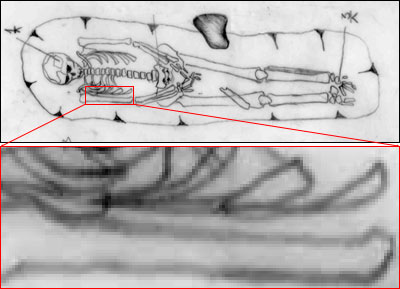
Aisling sent us a JPG file of a well-executed and attractive pencil drawing. Unfortunately her scan was unsuitable for raster to vector conversion because of the poor and variable foreground / background contrast, blurry lines and drawing elements with ambiguous paths (see image and detail below).

Small section of a much larger pencil drawing of an excavated ancient Irish cemetery, with zoomed in view showing the faint and undefined nature of the lines. Lines like this cannot be converted using raster to vector conversion. © Aisling Mulcahy.
We mentioned Arthur Batty’s method of making a copy, then inking over the original and scanning that. However, an examination of Aisling’s very detailed drawing of an ancient Irish cemetery showed the complexity of inking over so much fine detail.
“As for Arthur’s suggestion,” she said, “I had the same idea. I used a transparent acetate sheet and a fine marker to trace over all the details first. After scanning this, the results I got from Scan2CAD were excellent”. However, due to the time it took to carefully trace all the detail and to edit the results in AutoCAD – the vectorization with Scan2CAD was the quickest part – Aisling decided that this method did not save enough time.
This all goes to show that raster to vector conversion requires a scan with strong, well-defined drawing detail. While freehand archaeological plans drawn in pencil under difficult conditions on-site are unlikely to always provide such a starting point, it is possible to use them to create a suitable scan either by inking in the original or tracing over the plan on acetate. Depending on the drawing (Arthur Batty’s but not Aisling Mulcahy’s), this can save considerable time.
Since this user story was written, Aisling Mulcahy has reported to us that she is now getting much better results from Scan2CAD. See Irish archaeologists use Scan2CAD to document Iron Age trackway.

